Re: Maps Vs Years
May 24, 2011
It is interesting to note that the Golan Heights also fall outside the '1967 borders' and have been illegally annexed by Israel. Not much is mentioned about this Syrian territory in the statements by Obama, Netanyahu etc.
That will be an interesting part to watch. The rhetoric that Golan needs to be occupied because of security concerns is one that does not stand up to security - any missiles etc that can be fired from the 1967 border are just as devastating from the current border between Syria and the militarily occupied Golan. It is actually about the water.
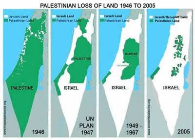
But coming back to the maps. Palestine as a country within the British Empire (or more technically, under a British Mandate) was well defined before the creation of the State of Israel in 1948.
Israel was created within the borders of Palestine, with 55% being allocated to Israel. The remainder was, and remains, Palestine. Wishful thinking and double-think can't change this simple fact - which is very clearly shown in the maps.
Cheers,
Shafique


